Jump to navigation
skip to main search
skip to main content
skip to secondary navigation
Search
Simon Fraser University
Engaging the World
Library
SFU Digitized Collections
This site
SFU.ca
Campuses
Burnaby
Surrey
Vancouver
A-Z
directory
Sign in
Connect
SIS
Canvas
Campuses
Burnaby
Surrey
Vancouver
A-Z Directory
a
b
c
d
e
f
g
h
i
j
k
l
m
n
o
p
q
r
s
t
u
v
w
x
y
z
Sign in
SFU Connect + mySFU
Student Information System
Canvas
Nav
You are here
Home
/
Bays (Bodies of water)
(x)
/
Islands
(x)
/
Aerial views
(x)
/
Business districts
(x)
Search results
(1 - 20 of 31)
Pages
1
2
next ›
last »
Title
Aerial View of Quathiaski Cove Opposite Campbell River, V.I., B.C.
Description
An aerial view of Quathiaski Cove opposite of Campbell River, B.C.
Date
1951,
Title
Aerial View Looking North, Vancouver, B.C.
Description
Aerial view of Vancouver, B.C. looking north. The North Shore Mountains are shown.
Date
1933,
Title
An aerial view of Brockton Point and the waterfront, Vancouver, B.C.
Description
View across Brockton Point towards North Vancouver
Date
,
Collection
Philip Francis Postcard Collection
Title
An Aerial View of the University of B.C. and English Bay, Vancouver, B.C.
Description
View across university towards English Bay
Date
,
Collection
Philip Francis Postcard Collection
Title
An aerial view of part of the business section of Vancouver B.C. showing North Vancouver
Description
View across Burrard Inlet to North Shore Mountains
Date
,
Collection
Philip Francis Postcard Collection
Title
An aerial view of the north arm of Burrard Inlet, Vancouver, B.C.
Description
View of an island in Fraser river
Date
,
Collection
Philip Francis Postcard Collection
Title
An Aerial View of the business section and docks, Vancouver, B.C.
Description
Aerial view of Vancouver, B.C. showing Burrard Inlet and waterfront area
Date
,
Collection
Philip Francis Postcard Collection
Title
Aeroplane view of Vancouver, B.C. Canada
Description
Aerial view of Vancouver towards North Shore Mountains
Date
,
Collection
Philip Francis Postcard Collection
Title
Aerial View of Alert Bay, B.C.
Description
An aerial view of Alert Bay, B.C.
Date
1940,
Title
Alert Bay, B.C. Air View
Description
An aerial view of Alert Bay, B.C.
Date
, 1950
Title
Vancouver, Canada From Grouse Mtn. Chair Lift
Description
Vancouver, B.C. viewed from the Grouse Mountain chair lift.
Date
,
Title
Alert Bay, B.C. from the Air
Description
An aerial view of Alert Bay, B.C.
Date
,
Title
Aerial View of Alert Bay, B.C.
Description
An aerial view of Alert Bay, B.C.
Date
,
Title
Aerial View of Alert Bay, B.C.
Description
An aerial view of Alert Bay, B.C. A large wharf and some boats on the water are shown.
Date
,
Title
Aerial View of Passenger Ship Entering the Narrows, Vancouver, B.C.
Description
Aerial view of a passenger ship entering the Narrows at Vancouver, B.C.
Date
,
Title
Aerial View of Coal Harbor, Burrard Inlet and Part of Waterfront, Vancouver, B.C.
Description
Aerial view of Coal Harbour, Burrard Inlet and part of a waterfront area in Vancouver, B.C.
Date
1941,
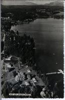
Title
Mill Bay Tourist Resort
Description
Aerial view of the Mill Bay Tourist Resort on Vancouver Island, B.C.
Date
1958,
Title
Aerial View of Lions Gate Bridge and Vancouver, B.C.
Description
Aerial view of the Lions Gate Bridge and Vancouver, B.C.
Date
1942,
Title
Aerial View of Coal Harbor, Burrard Inlet and Part of Waterfront, Vancouver, B.C.
Description
Aerial view of Coal Harbour, Burrard Inlet and part of the waterfront in Vancouver, B.C.
Date
1938,
Title
Aerial View Showing Brockton Point & City, Vancouver, B.C.
Description
Aerial view of Vancouver, B.C. showing Brockton Point. The North Shore Mountains are also shown.
Date
1946,
Pages
1
2
next ›
last »